
~1 gallon of water. I took a gallon and drank every drop. I left more in the car and kept drinking on the drive home.
~Plenty of food. You'll be on the trail through at least one meal, so pack a lunch and snacks.
~A handkerchief. I randomly put one in my pocket on the way out the door and was glad I did. Your nose will drip in the cold wind and you can use it to wipe sweat as you hike.
~Chapstick. The wind is brutal on the summit, and you'll be breathing hard through your mouth on the ascent.
~Jeans. I saw people wearing shorts, which is a huge mistake. It's freezing over the last 2 miles, and branches will be scratching at your legs for the first 3 miles.
~A jacket. You are far more likely to be cold than hot on this trip. I know you THINK you'll be okay, I think I'm pretty warm-blooded, too, but you'll freeze. It was 80 degrees on the valley floor when I did this hike, but there is no way the windchill on top was above 30 degrees.
~A camera. There are plenty of places to take pictures along the way.
~A flashlight or headlamp. Smart hikers leave well before dawn. I got to the trailhead at about 5:20 am.
~$6. There is a fee to pay to use this area. You'll want to leave early, before the ranger wakes up, so bring exact cash or a check.
 |
| This picture was taken with a flashlight because I got an early start. |
Be careful as you leave the parking lot. Right in front of you (from the "pay post") is the Stewart Falls trail. You need to go to your right. After about 100 yards, you'll come to a shed with a sign-in roster. I signed-in, which seemed especially important since I was hiking alone.
The trail is around 7.5 miles each way. The first 3 miles are through scrubby brush and small trees. The trail is narrow, but much of it is surprisingly paved (though long ago, so it's pretty crumbly). You'll come to two waterfalls which are quite beautiful later on in the daylight. I also saw a skunk on the trail, so keep your eyes and ears open.
 |
| The first waterfall |
 |
| The second waterfall |
On the way up the trail, you'll pass half of BYU's student body coming back. (Apparently the thing to do is begin the hike at 10pm and get back around 6am. They all had the same story, though: It was too cold and windy to possibly make it to the top). I'm not sure why anyone would want to take this hike in the dark. It would be a bit like going to a concert with earmuffs. I go hiking to see things. Also, many of them told me they lost the trail. That'd be easy to do at 3:30 in the morning! Oh, and they were all wearing shorts, of course.
 |
| Get an early start! |
 |
| This hike is very busy. I've heard it has up to 1000 people a day in peak season. |
 |
| See the goats. |
 |
| I took the binoculars, because the goats were pretty far away, but I wished I hadn't lugged them up the mountain. |
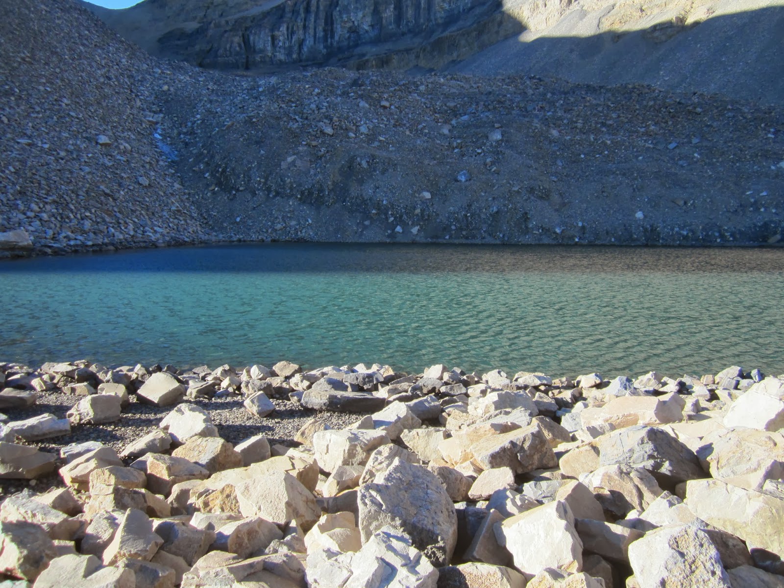 |
| Emerald Lake |
 |
| The shelter at Emerald Lake |
The next stretch of the trail is pretty flat, but not always easy. You start into a boulder field and the trail splits. The obvious route is down and right, but the correct route is up and left. The right fork takes you down into a wide valley and hooks on to the Timpanoeke Trail. You'll have to climb back out again on the other side. The left fork goes through a boulder field, which is a bit tricky, but eliminates most of the climbing. You'll want to stop somewhere in the boulder field for lunch. Eat, rest up, and get your jacket out. The wind is mostly calm, and the sun will feel nice.
 |
The boulder field isn't tricky, but the trail is vague. The Saddle is the blue sky on the top right.
|
The last climb to The Saddle out of the boulder field is the most difficult stretch of the entire hike. It's almost straight up, but only for about 100 yards. After the toughest stretch, you'll meet the fork for the Timpanoeke Trail. It's only a few more steps to The Saddle.
 |
The last steep climb from the boulder field to The Saddle.
Look closely, or click on the pic for full-size to get some perspective.
There are 2 guys standing up at the top of the incline.
|
The moment you step into The Saddle will take your breath away. A beautiful view of Utah Valley stretches from the windmills in Spanish Fork Canyon all the way to the Kennecott mine. The freezing wind will also take your breath away. Snap a picture or two and hustle up the trail to the left (south).
 |
| The Saddle from a distance |
It's VERY cold all along the west face of Timpanogos. You go south and then turn and climb up through a crack in the rock. It's almost like climbing a ladder. From here is a steady, frigid climb across granite crags to the summit. (They say it is almost a mile from The Saddle to the summit.)

 |
| This is right on top of the mountain. If you look at Timp after dinner you can actually see this shining white from the valley floor. |
 |
| Inside the shelter. It's pretty windy and cold-- and crowded! |
 |
| Out of the wind it is really pleasant. |
 |
| Looking down at Emerald Lake from the summit. |
 |
| Do not attempt to hike (or slide) down the "glacier!" |
 |
| You really think you're going to slide down that "glacier?" |
On the way down, don't forget to enjoy the hike. The goats and the waterfalls are waiting to be seen. It is far too easy to "zombie-walk" back to the car. Downhill is easy, and though you'll be a little sore tomorrow, you'll be glad you did this hike. Everyone should.
 |
| Enjoy the descent. |
 |
| It is really gorgeous in the high alpine valleys. |
Way to go, Randy!! It's Mark's and JJ's favorite hike! :)
ReplyDelete